Command and Control
EyeCommand is a Command & Control (C4I) suite that gives defence, peacekeeping and homeland security forces complete information superiority in the theatre of operations.
Fully compliant with NATO-standards and designed in conjunction with defence and homeland security experts, EyeCommand provides enhanced situational awareness across all levels of the command chain, providing a common operational picture that enables faster and better decisions at tactical and operational levels.
EyeCommand is made up of three unique, integrated and scalable systems. Defence, peacekeeping and homeland security organisations can combine all of these systems, for maximum strategic effectiveness, or take a one-platform-at-a-time approach to assist their missions.
EyeCommand fully digitises the defence, peacekeeping and homeland security operations by exchanging data securely, in real time, leveraging different types of communication channels and powerful interoperability mechanisms. It provides information superiority and an up-to-date picture that’s tailored to each command level, coalition partner, military and non-military organisations. Commands can be issued in real-time using an easy-to-use interface that’s been designed in close co-operation with defence and homeland security experts.
EyeCommand is a powerful ally in digitising operational scenarios and managing missions using a network-centric architecture.
EyeCommand for ground forces is a tactical solution, simple-to-use and optimally designed for lightweight devices and small screens, supporting dismounted operational elements which are engaged in these operations.
How can EyeCommand help you?
Improve situational awareness:
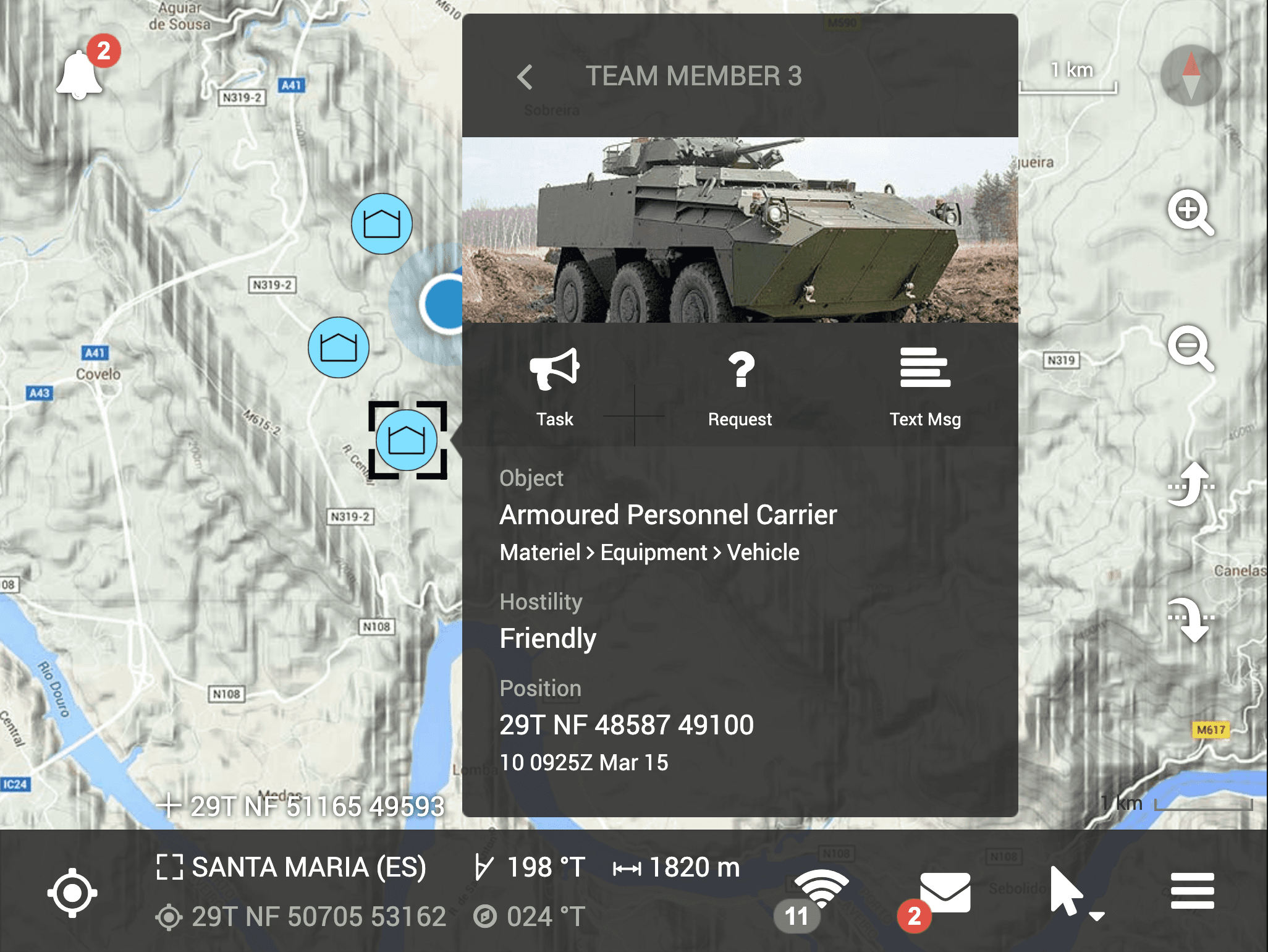
- Provides a common operational picture displaying adversaries, suspects, friendly and neutral organisational units, friendly and neutral non-organisational units, plans and orders, and globally significant elements using MIL-STD-2525 or APP-6 symbology.
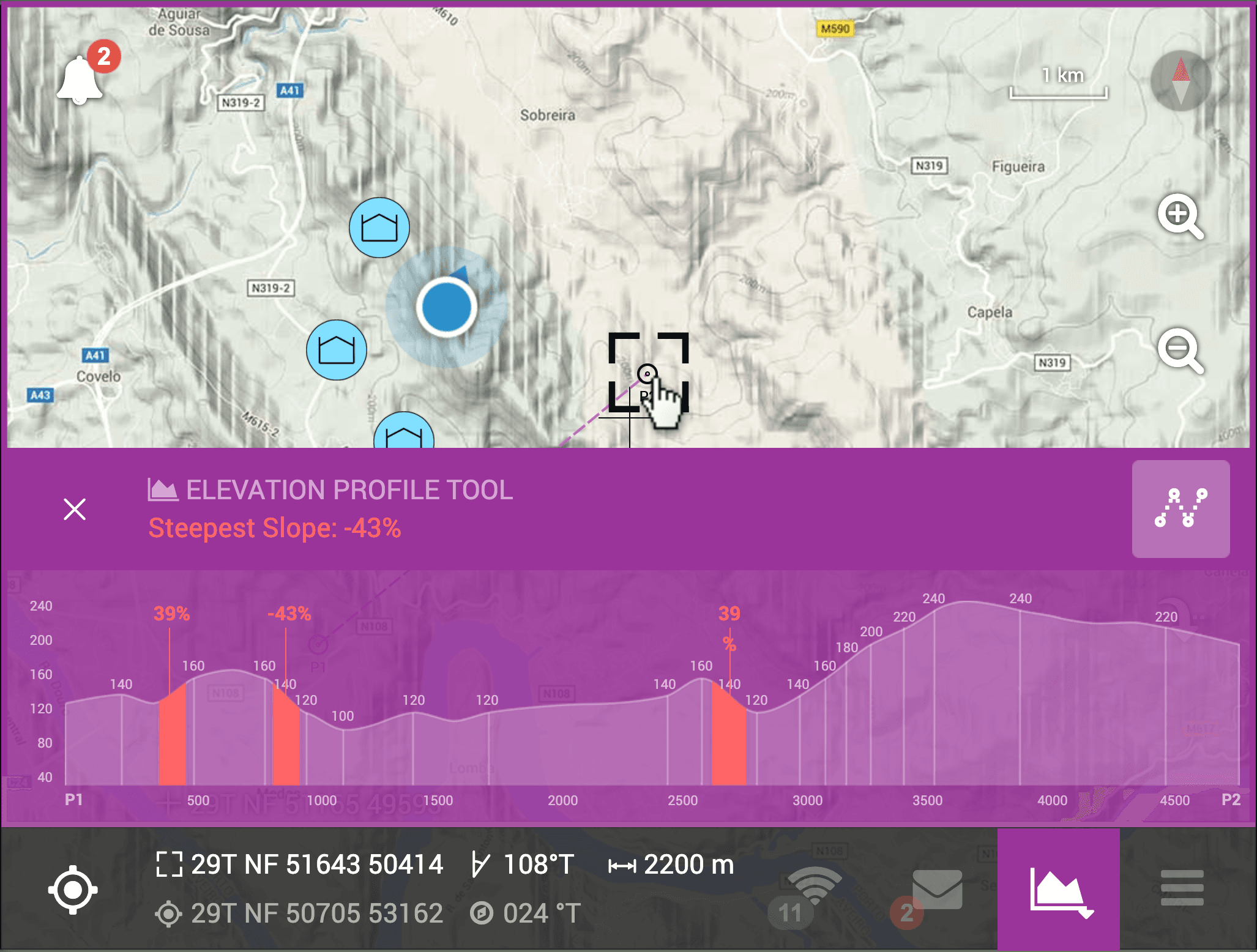
- Terrain analysis tools for the analysis and detection of elevation and high slopes, while also displaying visible and non-visible areas via a 3D GIS engine.
- Geo-fencing alarms which support the execution of planned itineraries, the identification of restricted areas, and the detection of abnormal tactical mobility.
- Chat and other communication tools using the NATO APP-11 message catalogue.
Integration with Soldier System:
- Leverages an Android device with small dimensions and supports usage with gloves and soldier protection equipment.
- Integrates with any NMEA GPS receiver, with any Personal Role Radio (UHF/S-Band) through serial connection and 4G/LTE/IP networks.
- Integrates with electro-optical and biometric sensors to provide superior situational awareness.
Increase interoperability:
- Interoperable with other systems through NATO STANAG 5527, the Friendly Forces Tracking System.
- Interoperable with other systems through NATO STANAG 4677, the Joint Dismounted Soldier System Information Exchange Model.
Tailored to the needs of your organisation:
- The modular set of features can be selected and configured to allow for a bespoke fit to the needs of your organisation.
EyeCommand for the battlefront is a tactical solution designed to be installed in vehicles and is designed to accommodate users wearing gloves or other protective gear while the vehicle is in transit. When integrated with sensors, it provides extensive support features for reconnaissance and surveillance activities.
How can EyeCommand help you?
Improve situational awareness:
- Provides a common operational picture displaying adversaries, suspects, friendly and neutral organisational units, friendly and neutral non-organisational units, plans and orders, and globally significant elements using MIL-STD-2525 or APP-6 symbology.
- Terrain analysis tools for the analysis and detection of elevation and high slopes, while also displaying visible and non-visible areas on a 3D GIS engine.
- Geo-fencing alarms which support the execution of planned itineraries, the identification of restricted areas, and the detection of abnormal tactical mobility.
- Chat and other communication tools using the NATO APP-11 message catalogue.
Integration with vehicles:
- Integrates with vehicle CAN network using J-1939 protocol, providing important logistical information for repair and assistance activities on the battlefield.
- Integrates with vehicle electro-optical sensors and radars providing superior situational awareness.
Hardware independence:
- Runs on Windows and Linux operating systems and integrates with any NMEA GPS receiver and/or Combat Net Radio (HF/VHF/UHF) through serial connection and 4G/LTE/IP networks.
Increased interoperability:
- Interoperable with other systems through NATO STANAG 5527, the Friendly Forces Tracking System.
- Interoperable with other systems through MIP ADEM.
Tailored to the needs of your organisation:
- The modular set of features can be selected and configured to allow for a bespoke fit to the needs of your organisation.
EyeCommand Vantage is a solution for all operational levels, providing HQ with command & control, information superiority and communications tools, such as Tactical Data Links and ISTAR capabilities.
How can EyeCommand help you?
Improve situational awareness:
- Provides common operational picture displaying adversaries, suspects, friendly and neutral organisational units, friendly and neutral non-organisational units, plans and orders and globally significant elements using MIL-STD-2525 or APP-6 symbology.
- Terrain analysis tools for the analysis and detection of elevation and high slopes, while also displaying visible and non-visible areas on a 3D GIS engine.
- Geo-fencing alarms which support the execution of planned itineraries, the identification of restricted areas, and the detection of abnormal tactical mobility.
- Chat and other communication tools using the NATO APP-11 message catalogue.
Improve planning:
- Creates and disseminates plans and orders using an intuitive user interface. Details superior echelon plans for distribution to lower level echelons.
- Manages personnel, facilities, and equipment in an integrated way to evaluate and optimise resources to be used in each mission.
Improve intelligence:
- Integration with external tools to provide information correlation and fusion, providing superior intelligence.
- Integration with surveillance, target acquisition and reconnaissance systems.
Improve debriefing:
- Provides statistical reports to help commanders identify risk factors and behaviour and incorporate these into preventative strategies.
- Replays previous missions and exercises for analysis, debriefing and training.
Increase interoperability:
- Interoperable with other systems through NATO STANAG 5516, the Tactical Data Exchange - Link 16.
- Interoperable with other systems through NATO STANAG 5518, the Interoperability Standard for the Joint Range Extension Applications Protocol (JREAP).
- Interoperable with other systems through MIP DEM 3.0.
Tailored to the needs of your organisation:
- The modular set of features can be selected and configured to allow for a bespoke fit to the needs of your organisation.
We’ll be glad to help you on any subject we can.
If you wish to contact us, please fill in the form or send us an email at [email protected]